Recently Viewed ›
Recently Downloaded 
Close x

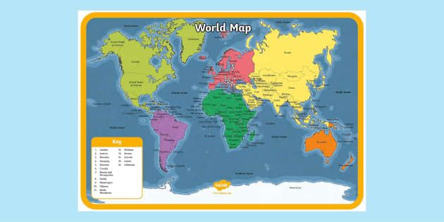
This is a fantastic editable world map with all the country names for helping you teach your children global geography.
 world map
 with countries
map
maps
world map a3
atlas
map of the world with countries
world map with equator
globe
world maps
countries of the world
europe map
world map with countries labelled
geography
world map
world map with countries
map
maps
world map a3
atlas
map of the world with countries
world map with equator
globe
world maps
countries of the world
europe map
world map with countries labelled
geography
Thank you. Very helpful
Thanks it is very helpful
The children found this map confusing because The Baltic countries are labelled on the Russian territory. Had to explain what the colours mean and where the countries are.
Wall display for where do we come from.
Hi nhartell,
Thanks for commenting! I'm glad to hear that this resource will be so useful :)
 Emma.hermiston@Twinkl 6 years ago
This is a fantastic editable world map with all the country names for helping you teach your children global geography.
The map is colour-coded with a different colour for every continent, so you can give your children a bold overview of the way that countries are categorised into groups.
There are numerous versions of the poster to suit your needs. Use the 2xA4 version to easily print a large version that you can glue or staple together before you include it in a colourful display. Or use the 2xA3 version if you want smaller copies of the map that you can pass around the class.
The editable world map comes with country names, but in its interactive form, you can choose to delete all or part of the country names to make this into a fun world geography quiz. Or, you can add more detail to the countries, such as flags or population sizes.
There are indeed. World geography is a hugely important subject that will benefit children throughout their lives. That’s why we have a diverse collection of resources, designed by qualified teachers, for teaching your kids about countries all around the world. Have a look at what we have to offer:
This seems like an obvious question, but depending on who you ask, the answer will change. Our editable world map suggests there are indeed seven continents. But using the definition of a continent - a continuous tract of land - some would suggest Asia and Europe are the same continent.
This is why places like Russia and Japan believe there are just six continents because they use the term Eurasia for the combined continent of Europe and Asia.
 Home
Home  Membership
  Customer Support
  Create
  Blog
Blog