Yesterday we woke in Gorkha to head to the epicenter. We had felt 2 small aftershocks during dinner, and a third woke us in the night. Everyone here was very scared and morale was low. Their world heritage site, the castle of the king who united nepal, was heavily damaged and closed.
Damaged heritage sites- a source of much of their tourism and incomeDeepak got us access to this castle- now closed due to damage- with his university credentials.
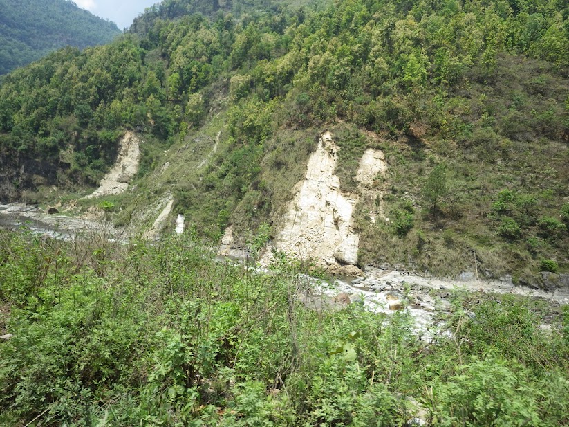
We were 16 km from the epicenter, and the drive took 7 hours including stops for lunch and to document damage. The road was really rough, but the countryside was the most beautiful we’d seen yet. No trash, bright green rice and corn fields, huge rivers, and towering mountains. All long the river and mountains there were small slope failures, mostly rock falls from the earthquake. Some were actually pretty big, but the nature of the hard bedrock everywhere here seems to limit their size to some extent.
Landslides along the riverTractor destroyed by a rockfallMassive slope failures are commonLandslides in the beautiful countryside
We stopped at a lot of the villages. I spoke with a bunch of kids.
I’d say “namaste saati.”
They’d reply “hi!”
“Where are you from? What is your name? What is your mother’s name? What is your father’s name?” They’d ask me.
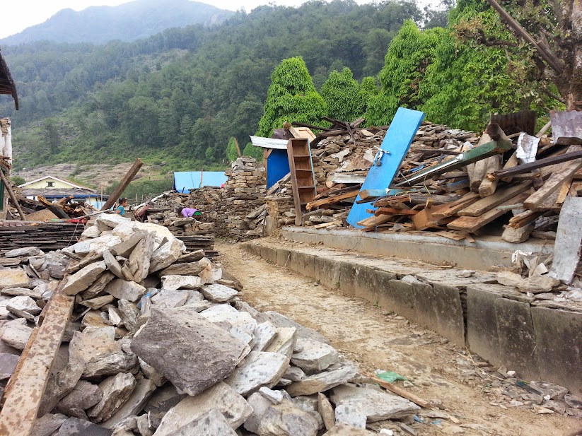
Their school was destroyed, and several of their homes, but luckily nobody was killed in this village.
Many houses in this area were destroyed. In some villages almost all, in others maybe only half. All the schools we saw were destroyed.
Ruins of a shop
After gut pounding hours of bouncing down the road, then climbing almost straight up the side of a mountain in our truck, we made it to Barpak.
Hard to see- but note the colored dots- those are tents, indicating destroyed homes. This village is only accessible by footpaths or helicopter, and is not as remote as others which cannot be seen from roads at all. The terraces are amazing, dropping down 1200+ meters to the river below.
We were immediately greeted by a pack of boys who jumped on our bumper and rode into the village, they thought it was a great game to ride the aid trucks up and down the mountain. Almost everything here was destroyed. It was raining. A few hundred people were gathered in the town center having aid distributed. Nearby was the ruins of their school.
Boys chasing our truck. They would ride aid trucks up and down the road for fun. Hard to imagine how bad the situation was in town until we got there.Destroyed homes in Barpak
A member of the APF told us 1200/1400 homes were destroyed, and 71 people were killed. He said in another nearby village, 2 hours away on foot, all but 2 homes were destroyed.
Somehow still smiling
Talking with the Armed Police Force (APF)
I probably have 100+ more photos like this
All the buildings in this small village were flattened- likely ridgetop shatter/amplification effects.
As we walked through the ruins of the village, people and soldiers were busy rebuilding. Tents were everywhere. Helicopters and aid trucks were coming and going. We were 1200 m above the river, and as the clouds cleared we could see snow capped mountains that were probably another 4000 m above us. This village has road access but we could see villages across the canyons that did not and were dotted with brightly colored aid tents, indicating their buildings were also destroyed. It was a really emotional scene, but we were again completely struck by the resilience of the nepali.
People gathering to receive aid distributions. Concrete reinforced structures were the only ones that survived in Barpak- however if the earthquake had been a little larger, these probably would have been destroyed also.
Everyone was working together to rebuild. People offered us lunch as we walked by. A woman Deepak spoke with who had lost 2 relatives offered us tea. This was the hardest part of the trip for us. I was brought to tears several times looking out at the scene over the village.
Truly humbling to be offered lunch by these guys. (we refused)
Deepak had spoken with us the night before about setting up a fund to help support orphaned children through school. We plan to do this and will have a PayPal account setup when we get back to the states. The money will be invested locally with no overhead and manged by Deepak who is a local professor. The interest will be used to support children here who have lost everything. We hope to raise around 10k, and ask our friends to put their week’s beer money towards this cause, as a little goes a long way in this country.
No words
Today we return to Kathmandu, and tomorrow night we fly home. We’ve heard that almost a million people have left the city (of 4 million) so we’re not sure what to expect.
On May 12, Wesnousky left around 7 am. We woke in Kathmandu and hired a taxi to drive us around the city for our chimney surveys. We measured the orientation that these chimneys fell to see if it would make a pattern that could give insight about how the earthquake waves traveled through the kathmandu basin. Near these brick factories, the people were mostly very poor Indian immigrants and low caste nepalese. It is sad to see the slums that they live in, but their children were all still smiling and playing and it is beautiful in the areas they live, around the outskirts of the city, as opposed to the grit of the more dense urban areas.
Brick kiln chimneyAsking locals which way chimneys fell
Around 1pm, we were hiking through a field between chimneys when we heard a commotion. Dogs were barking, birds were making noise, and goats were bleating. A second later the ground started to move, it was pretty violent and hard to stand for almost 30 seconds. The chimney we were heading towards had a few hundred bricks fall off of it. Next to us there was a small pool of water and waves formed in it- a seiche. On he horizons we saw several clouds of dust from the city – buildings collapsing- and in the mountains – landslides. For several minutes we felt waves coming in, it was like being on a boat. We were probably getting moved around close to a half meter or more with these waves, but it was silent, subtle, and we couldn’t see anything but the water splashing. It felt like we were really drunk and it was difficult to walk. For the next hour we kept thinking the ground was shaking, and at times it was. We estimated the first quake as an m 6.x, it turned out to be a 7.3.
We saw lots of copters after the 7.3.
People ran out of their houses and sat in fields with umbrellas. We quickly finished up our survey at that area and got in our car to head to lunch then the next survey area. Driving through the city was nuts. Everyone was in the streets, either in cars trying to get home or sitting next to the road or in the medians. All the restaurants we tried to go to were closed. We drove all the way across kathmandu to the eastern part for our surveys and only saw one newly collapsed building, which was truly amazing. The traffic was really bad as it created problems for emergency vehicles trying to cross the city to get people to hospitals.
Lists of survivors and deathsPeople gather in the streets, afraid to go inside.
After finishing our survey around 5, we drove back to our hotel. Everything was closed, and many of the guests were checking out. People were really scared. When they found out we were geologists, they would ask us what was going to happen. We really have no idea, but were (are) scared ourselves. I noticed a lot of new, but minor, cracks in our hotel. Some of the other Americans there asked us if it was safe. We said probably, but that we have no idea what would happen. All the hotel workers were in the lobby playing poker and watching the news. Around midnight we did a few video chat interviews and then went to sleep. We slept with our bags next to our beds and ready to go.
People sleeping outside again
Steve woke me up at around 3 am and I felt a shock, that felt like some of the big waves from the 7.3. I put my helmet on and tried to sleep. I kept waking up in extreme fear and thinking there was another earthquake.
Cracks in hotel
Around 5 am we got up and had breakfast. Our plan was to leave and head to pokhara for a day of downtime then head to gorkha, near the epicenter. The American girls we met the night before said they left in the middle of the night during the big aftershock to camp out in the open. Everyone was terrified, but the resilience of the nepali people is really amazing. They are determined to rebuild, but also extremely angry with their government for assuring them that there would be no more earthquakes. This will probably cause tension going forward. People are really scared and on edge though, it’s a hard atmosphere to describe. Walking around thamel which is usually a bustling tourist area, and was starting to return to normal before the 7.3 was dead.
Building from first night is continuing to fail
Dipendra arrived and we got on a local bus to go to Pokhara to take a day off and escape the tension and aftershocks, we later learned that there were around 50 over M4 in the first day. The local bus ride was brutal after hardly sleeping. It was a small van packed with about 20 people for 6 hours through the mountains. I was starting to lose it when we got there, so went on a walk and got a tuborg. I found a restaurant with a view of the lake and watched the sunset. Unfortunately I’d broken my camera lens 2 nights before. I then wandered around the streets, talking to people and taking in the town. It was amazing how there was no damage here even though pokhara was the same distance away from the epicenter as kathmandu, although the fault ruptured the other direction. People here were hurting economically though. It is the middle of the tourist season and nobody is here, and that is normally huge business. We saw a woman wearing a helmet inside a store.
Crazy van with 20 people through the mountains Pokhara is beautiful, especially after the devastation in kathmandu
This earthquake series is unnerving for us as geologists. Everest and the high Himalaya are some of the fastest growing mountains in the world, but they went down in this sequence. The HFT has huge scarps presumably from paleo earthquakes. However this earthquake did not rupture the HFT to the surface. We don’t totally understand it but it’s plausible that it has increased stress along the front, which would lead to a larger earthquake. We have no idea when that would happen, but it has happened historically.
The humanitarian situation in Nepal is also complicated. Kathmandu was starting to seem normal, although many people are living in dangerously damaged buildings, and have lost power and water. Now everyone is scared but lucky that there has not been more damage. The 1505 quake killed 30% of the population of Nepal. We expected much worse from this quake. Many of the world heritage sites have been destroyed which will have a lingering impact on their tourism industry for years to come, which is one of their biggest economic drivers after remittance. Many people are again sleeping outside out of fear for more earthquakes.
There are about 2200 rural and difficult to access villages that have been partially destroyed and cut off from the world. These people are in desperate need of aid. Much of the aid that is coming in is disorganized and ineffective. Furthermore, they need to quickly rebuild as monsoon season is coming soon and the situation will worsen if people are exposed. They need to rebuild with earthquake resilient structures though which requires training and consulting from engineers. I don’t think this is happening at the scale it needs to. People want this help and understand this need, but it’s not there.
Even further complicating this, there are many recently activated landslides that will become serious problems once it starts raining in a few weeks. I fear many more people will die from these.
Tomorrow, we travel to gorkha, the epicenter, and we will see first hand the damage that has happened in these areas.
May 9
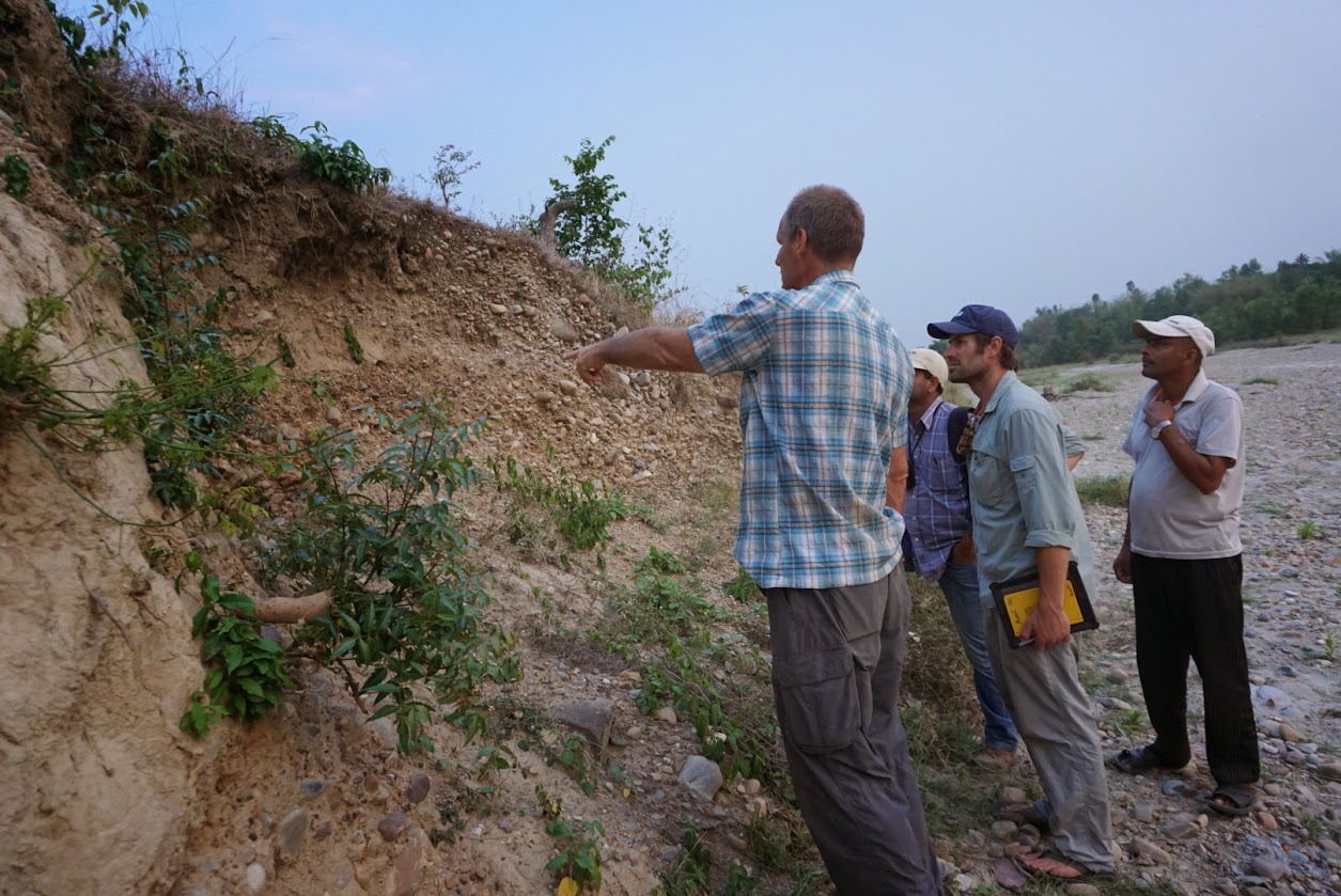
We woke up in Bardibas at the nicest hotel we’d stayed at since leaving Kathmandu. We immediately drove a few km’s to a series of HFT fault scarps that Bollinger et al. had mapped. Some of these scarps were multi event scarps >20 m, but some were very similar in form to the Lave et al. scarps that we had looked at the previous day, ~4m high with some geomorphic development. This was difficult for us to resolve as we aren’t calibrated for the geomorphic rates in this area- we are used to looking at scarps in the desert, and not in the Himalaya with meters of precipitation per year- essentially, we weren’t sure if significant channels are able to be form in the 81 years since the 1934 earthquake occurred in this region, which Bollinger argues is responsible for the scarps here, but Lave et al. argue that similar scarps ~20km to the north are from an 1100 A.D. earthquake. A lot more work needs to be done in this area to resolve the paleoseismic record.
A rural Nepalese village along the HFT
We continued east to a trench site that Deepak and Kumahara (from Hiroshima) had dug a few years previously. There trench was filled in, but the river (technically a khola – Hindi for intermittent stream) had exposed a cut through sediments which showed the Pliocene-Pleistocene Shiwalak formation in an angular unconformity below Holocene-Pleistocene fluvial gravels. The Shiwalak formation makes up much of the southern Lesser Himalaya, and is essentially a sequence of Himalayan fluvial deposits- similar to what is now found in the plains below the Himalaya, but now lithified, lightly folded, and tilted- in this area they were south dipping.
We drove back to the highway and headed west. The highway here is a two “lane” road that is essentially the i5 of Nepal. However, it is very slow to drive on, occasionally (and without signs) turns to gravel, has goats, cows, pigs, chickens, dogs, monkeys, children, tractors, buffalo carts, bicycles, trucks, busses, motorbikes, and cars traveling on it without many rules. It is slow going, but is faster than driving in the mountains. Everyone is constantly honking and driving around eachother.
We saw a few chimneys from brick ‘factories’- essentially large kilns where they use coal to bake local sediments into bricks. We are starting a project to map the orientation that these chimneys fall- we hypothesize that they may indicate the direction of strong motion, but we need to test this with real data. Most of which we’ll collect in Kathmandu, but the 6 or so chimneys that we found on the plains are worth noting.
Broken Chimney
This took a few hours, and then we stopped for lunch. The traditional Nepalese lunch is dal with rice and some vegetables. It is very good and heavily spiced.
We continued west, and went to a few new spots to look for possible future trench sites, as well as to check for surface rupture- although at this point we’d already checked the most likely locations. The best elevation data we have in this area is SRTM (Shuttle Radar Topography Mission) data which is 90m resolution. Its like looking through foggy goggles compared to the 10 or 1m lidar data we are used to working with. The first site we went to was a bust. The second site was informative, but also not a good trench site. There were 4 or 5 flights of terraces above a beautiful village (all of the kids here’s smiles are amazing). The first two terraces were back tilted close to the fault scarp- which is what is expected in a thrust fault, but was very cool to see demonstrated.
The HFT behind a rural village
It was getting dark at this point, so we got back in the car and drove west another few hours, stopping for chai with buffalo milk (standard), and finally got to a hotel in Hamauda, which is a little bit into the mountains again.
May 10
We woke up and started driving again, this time heading west to Bharatpur Dun (Dun means valley in Hindi). This is an unusual basin which is behind the HFT, but before the MBT – the next major thrust fault in from the HFT. We stopped for breakfast- this was the biggest city we’d been in since leaving Kathmandu. There wasn’t much noticeable earthquake damage here- like most of the south.
Ian, Steve, Steve, and Deepak
We continued driving, we planned to make it to Kathmandu that night, and it was a long drive (despite the relatively short distance) across the mountains. We stopped to look at an exposure of the MBT. It was highly sheared material- it actually looked a lot like the ‘blue goo’ of the Franciscan formation in Northern California. The fault had essentially taken whatever rocks where here and pulverized them into a weak clay-ey material.
Wesnousky in front of the shearzone of the MCT.
We continued driving- next stop was a few outcrops of the MCT- the next thrust inbound from the MBT. Here we looked at high grade metamorphic rocks- spotted hornfels, gneiss, garnet schists with beautiful folds. We gave a bunch of chocolate to local kids here and it was fun- they know the word chocolate and would come running to the truck. This site was where Deepak’s university takes their students to do field mapping. They spend 3 weeks doing a strip map across the Himalaya- which is incredibly impressive if you could see the terrain. The roads here have 1000′ near vertical drops down to the rivers, and thousands of feet up to the tops of the mountains. There is tons of vegetation, and it must be quite challenging to map.
Steve Angster looking at the high grade metamorphics of the MBT.
Finally we started to get close to Kathmandu. We could tell there was more damage than there had been in the south. As we were driving in, we saw a bunch of ambulances, and Deepak got a phone call. Apparently there was a M 4+ aftershock, which with the state of many of the buildings (not collapsed, but damaged) could easily injure or kill people.
Buildings with this much damage are uncommon.
We stopped at Deepak’s university. His geology department’s building had been condemned. Interestingly, it was built in 1918- and it survived the 1934 earthquake (although a clock tower fell, which was rebuilt, and didn’t fall this time). We saw many of the other government buildings which had been heavily damaged also- although all were still standing.
Tribhuvan University Geology department building- now condemnedTribhuvan University. This tower was destroyed in 1934 but survived 2015. The building (built 1918) survived 1934 but was condemned in 2015.
We finally made it back to our hotel in Kathmandu, and after discussing our plans, took a few hours off to explore the area around our hotel, the Thamal district. It was interesting talking to people here- they all spoke English, which was very different from the rural villages we’d been in the past few days.
I met a girl who asked me about the earthquake. She worked at a non-profit women’s center, and was very concerned about problems in Nepal. She talked about how she had plans to go help out in some of the rural northern villages, which apparently had been hit the hardest by the earthquake. People there are wondering how to rebuild- as they need shelter quickly, before the monsoon season hits in the next few weeks. There are shelters and aid coming in, but not enough. I wasn’t sure what to tell her, I’m not an engineer, but the unreinforced or lightly reinforced masonry in the cities performs very poorly in earthquakes, and there are not many materials, or even if there were, there’s not enough money to build better homes with. In villages, there are likely ways that houses could be built better (check out NSET – they have publications about this) but people lack the knowledge to do so. From others, I learned that there are about 2,200 affected villages, and nowhere near enough engineers or materials to help people rebuild in the time they need to. Furthermore, there are significant landslide problems that were initiated by the earthquake, but will be greatly exacerbated by the coming rains. It really does sound like a desperate situation in these areas.
Steve brought a tent to donate for relief, and we gave it to Nasreen who is heading north to help with aid efforts tomorrow.
May 11
Our plan for May 11 was to map a large set of ground cracks that follow a trend in Kathmandu. We met with Dipendra Gautam- a student of Deepak’s. He is a civil engineer, and would be our guide for the next few days.
Dipendra – awesome civil engineer
We headed to the area with the cracks, which was southeast of the airport in Kathmandu. We began mapping and talking to locals. They all wanted Dipendra’s opinion of their houses- many of which would be immediately red tagged and torn down were they in the US, but here, nobody has anywhere to go or money to do anything about it. Everybody was interested in what we were doing and were very happy to show us what they saw and describe their experience. Again, there were tons of smiling kids- apparently a theme in Nepal.
Dipendra and Steve showing a local what we were doing.Smiles for miles
We spent most of the day doing this, moving from street to street, making a map and taking pictures of the cracks (some were >1.5 m in height).
The people I talked to today seemed to be most conce
Major ground cracking. This damaged a lot of structures.
rned about the damage to the World Heritage Sites in Kathmandu, which attract many tourists and are a significant economic driver. Everywhere we went, people were trying to rebuild.
RebuildingA newer member of the local earthquake early warning system – we’ve heard reports that dogs here react several seconds before P-waves hit from aftershocks.
Some houses were rotated or tilted, but very few were destroyed. My estimate is that less than 1 in 2000 (0.5%) of houses were totally destroyed. Some of the tilted homes were probably put on end about 15 degrees, which makes them uninhabitable but probably didn’t kill anyone. Fortunately there aren’t any gas lines here- no fires. We also didn’t find any evidence of liquefaction- which plagued Christchurch after their 2010 earthquake sequence. The GPS data and these observations suggest that the earthquake was very gentle- it moved the surface a lot but relatively slowly. For example, we spent a day investigating the 2014 Napa earthquake this past Fall, and everywhere we went there were tons of broken wine bottles, but here, even in a building that was partially ripped apart by cracks, there were intact bottles sitting on shelves. It really is amazing. People need to tear down their homes and rebuild, but it seems unlikely that this will happen at the scale it needs to. Hopefully another large earthquake won’t happen for a while, but nobody really knows.
Fortunately nobody died- and more fortunately this level of damage is uncommon.
Despite all of the hardship, people were still very generous- we were invited to have tea with a family who’s building had been heavily damaged.
Steve mapping cracks.
At the end of the day, Dipendra took us on a bus- which was quite the experience- and then we walked through one of the world heritage sites that had been destroyed on the way to our hotel. We also saw a large tent camp where some people were relocated to. The city really seems to be getting back to normal, despite the damage and uncertainty. This isn’t to say they don’t have problems and they don’t need help- they do, but it seems that people are trying to get on with their lives.
Many of the world heritage sites in Kathmandu have this much or worse damage.Large tent city of displaced people.
Tomorrow we will spend mapping chimney damage throughout the basin. In two days time we plan to head towards the epicenter – Gorkha – and will then probably see the really badly damaged areas.
In the morning we had breakfast at our hotel and then met with Dr. Deepak and Roger Bilham. We then met our driver and packed into the small SUV we’d be taking down to the Himalayan Frontal Thrust (HFT). We drove through kathmandu and got a glimpse of the damage. While many buildings were damaged, the vast majority were not. We saw many sights and smells. The traffic was very light we were told, as many people had left the city.
Destroyed apartments near our hotel
We climbed out of kathmandu, and stopped at several overlooks. We were again surprised by the lack of damage when compared with our expectations from news reports. For a city of 4 million built out of primarily lightly reinforced masonry to survive an earthquake of this size with fewer than 3000 deaths was very fortunate. At the same time it is a great tragedy for those who did lose their homes or family members.
We expected buildings like these to be mostly leveled from media reports.For many earthquake damage is very real
We continued driving through the country side. There were houses andsmall villages everywhere, and occasionally we’d see some earthquke damage. There aren’t really any open spaces here like in the us. There are small farms, houses, and people in every corner. The road was fairly rough, and very steep and narrow, with a lot of traffic- busses and trucks zipped by inches away from our truck. There were many other small SUVs, motorcycles, bicycles, pedestrians, goats, dogs, chickens, ducks, cows, and water buffalo along the road.
We stopped and checked out a dam which appeared undamaged. We had lunch in a small village a top a mountain.
After 4 or 5 hours of driving, we got out of the lesser Himalaya, and the road became very flat and fast. We began heading east towards a large fault scarp of the HFT that Steve knew of. On the road we saw a dead child that must have been hit by a car, this was definitely the most depressing thing we’d witnessed. When we got to the scarp, we talked to the locals who were living there, and asked about the earthquake. They said they felt strong motion, but only one building was damaged, and nobody was killed. We looked around and found no evidence for surface rupture. We drove a few more kilometers to a guest house in a small village called Naya Road, where we spent the night. It was very hot and humid in this part of Nepal, as we were out of the Himalaya, and close to India.
Deepak heard reports from locals of surface rupture to the east, where we thought there might be some as it was predicted by models. We will head to Hariwan tomorrow to investigate.
Day 2
Today we woke up around 0430 and we’re rolling by around 6. Our primary objective was to follow leads that Deepak had heard of the night before regarding surface rupture from the earthquake. We skipped breakfast and just had the customary tea, which is similar to chai.
Our first stop was a few kilometers outside of Naya Road, to get a detailed description of what a man had seen. We met with him in the courtyard of his house, and spoke for a while. We learned that large cracks had formed during the earthquake a few kilometers away. Before chasing those, however, we investigated the direction that several large, 40 meter tall brick furnace chimneys had fallen, as this could potentially indicate strong motion directions.
Another man showed up, and we followed him up towards the mountain front. We eventually got to a small village, Atrouli, where the rupture supposedly happened. A whole gang of villagers led us up the mountain to a very large landslide complex. There were two main rotational blocks and many >2 m deep cracks. The left lateral scarp and head scarp had exposed failure planes that were heavily slickensided with a 10 m tall scarp and >15 m long slickenlines. We were very worried about the village below, as during the coming monsoons, the slide will likely reactivate and take out the village. We explained this to them, and hopefully they will pay attention to this slide. Unfortunately for us, this was not the surface rupture we were looking for, but cool none the less. The villagers also told us that their river was dry before the quake and was now running, so perhaps some good came. It was really hot and humid climbing around the mountains.
Massive coseismic landslide that villagers reported to be surface rupture.Dr. Deepak explaining the danger of the slide reactivating during coming monsoons.Landslide destroyed house. Nobody was killed, fortunately.Biggest slickensides we’ve ever seen in a slide.
The village makes their money farming mangos, and they were predominantly Buddhist. We met a bad ass lady named Harimaya who owns a farm and is head of her household, which is very rare in Nepal. She was very nice and made us tea, fresh bananas, and gave us beautiful red, gold, and white scarves. She said she was involved with OXFAM.
The generosity of these people is humbling.Harimaya
After talking with the villagers for a while we continued on our mission to investigate the HFT. We stopped for lunch- the food here is amazing. We went to the trench site from Lave et al., 2005, and looked at the scarp which they attribute to the 1100 AD earthquake. It was about 4 m tall, and their trench indicates 17 m of slip. The earthquake that generated it was likely ~M8.8, 30 times more energy than the recent earthquake. I tried to ride a water buffalo after asking a kid I saw do it, but no luck, and I narrowly avoided being trampled.
Next, we continued on to the trench sites from Bollinger et al., 2014. They present evidence that the 1934 earthquake did in fact rupture the surface, but the scarp we looked at was suspect. We also met more cool villagers. The kids smiles here are amazing, and there is very little earthquake damage in this area. All together we covered about 50 km of the fault.
The main Himalaya Frontal Thrust. Most of the Himalaya are built by this fault.Trying to ride a buffaloBollinger’s river cut of the HFT.Discussing the HFT Wesnousky making friends
We got to our hotel in Bardibas around 2000, and it is very nice compared to last night, and even has a/c and wifi. Tomorrow we’ll keep investigating Bollinger’s work, and keep looking for surface rupture, but at this point we haven’t found any, and it seems unlikely that we will.
We landed last night after over 24 hours of traveling. We took a taxi to our hotel in the Thamal district. There is a lot of damage to structures, but I am more surprised by the relative lack of damage. Most of the city is more or less intact. The tourists have mostly left though, so the streets are pretty empty, and shops are closed.
We met up with ouradvisor, Steve wesnousky, and today we’re hiring a truck and heading a few hundred km south to investigate the Himalayan Frontal Fault (HFT). We will be down there for several days, so I am not sure if we’ll have Internet access.
Undamaged, but empty streetsMeeting with WezChinese military jet delivering aid suppliesBroken brick buildings are commonMajor structural damage to apartments near our hotel
The Himalayan mountains represent the collision zone between the Indian and Eurasian plates. Here, strain accumulates at ~3.8-5 meters per century as the Indian plate subducts beneath Tibet. Approximately half of this, 2 m per century, is accomodated by the Main Himalayan Thrust Fault (MHT), which extends along the Himalaya front from Bangladesh to Pakistan. This accumulated strain is released as earthquakes that uplift the mountains cm to meters at a time. Paleoseimologic studies and historical records have provided evidence for several large earthquakes (M >7) throughout the past. These studies have also shown that the MHT ruptures in segments, which are generally about 200 km long, but can be up to 800 km for the largest events (~M8.8). The record has major earthquakes at 700 AD, 1100 AD, 1255 AD, 1505 AD,1555 AD, 1803, 1833, 1905,1934, 1950, 2001, and now the recent 2015 Nepal M7.8 earthquake. Understanding the location, timing, size, and frequency of past earthquakes is very important for determining future hazards in the Himalaya, one of the most seismically active and densely populated parts of the world.
Some of the larger (~M >8) earthquakes have ruptured the surface of the earth as much 17 m and can be traced for hundreds of kilometers. Historical records, however, have indicated additional large events, similar in size to the recent 2015 event, that lack associated surface rupture. The 2015 earthquake ruptured about 150 km of the plate boundary interface, filling a seismic gap between the 1934 and the 1505 rupture zones. It is unclear from the rapidly acquired geophysical data and satellite imagery whether or not there is surface rupture. The objective of this expedition is to determine if this 2015 earthquake ruptured the surface, and if so, how extensive it is. Understanding how this earthquake affected the earth’s surface will help us understand how past and future earthquakes behave, which will help the Himalayan region and greater Indian subcontinent prepare for future disastrous earthquakes.
Steve Angster and Ian Pierce are heading for Kathmandu via Abu Dhabi and SFO on Tuesday 5/5 at 9:35 AM.
We’ll be on flights EY 182 and EY 292, and will land in Kathmandu at 20:20 local time on 5/6.
We plan to meet our advisor, Dr. Steve Wesnousky at the Tibet Guest House (tibetguesthouse.com). He is arriving in country on 5/3 at 15:25.
The last few days we have been preparing, shopping, creating maps, and trying to figure out what to expect and look for when we get on the ground. We’ll add more preparation and background photos in a later post, but I wanted to get this started sooner rather than later.
Here is a picture of most of the stuff going in Ian’s backpack: