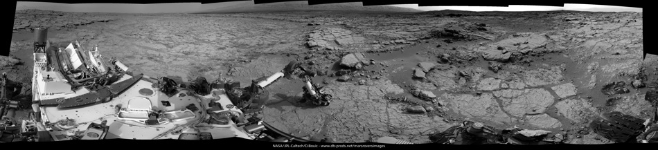
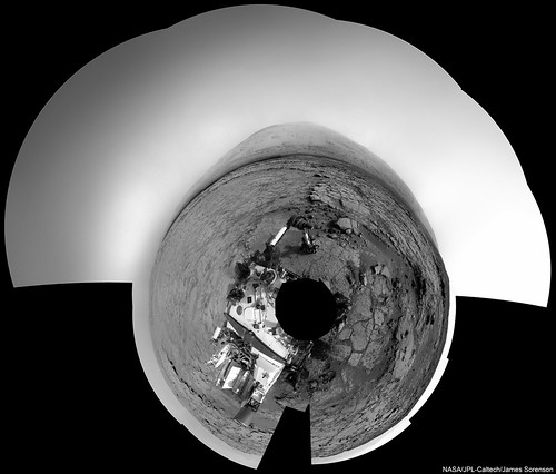
Sol 166 NAVCAM Left view. This one went down kicking and screaming; tons of parallax with such close in images....
Click to view attachment
Airbag
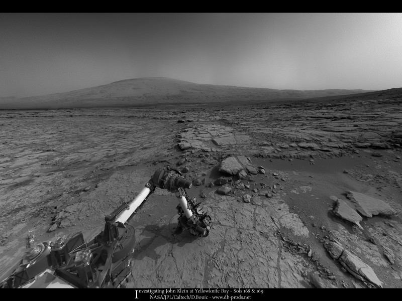
Full Version: First drill stop: John Klein in Yellowknife Bay
New foreground details from Sol 166...
MC 100 (6902 x 5418 px - 5.4MB):

MC 34/100 anaglyph (6902 x 5418 px - 6.74MB):

MC 100 (6902 x 5418 px - 5.4MB):

MC 34/100 anaglyph (6902 x 5418 px - 6.74MB):

I was hoping for something like that as well! Shooting images rapidly as the rover is driving - then making it into a movie like we did with the MAHLI images. It would be incredible to see a motion picture like that from Mars!
And my take on Sol 166, MR. GigaPan - while I'm here :
:
http://gigapan.com/gigapans/122180
And my take on Sol 166, MR. GigaPan - while I'm here
:http://gigapan.com/gigapans/122180
Here's a MAHLI mosaic made from some of today's (Sol 168) MAHLI shots:
http://i.imgbox.com/acpwtCWL.jpg
http://i.imgbox.com/acpwtCWL.jpg
Nice Ed. Mayhap it is just that I am more comfortable with false color manipulation of Opportunity's images compared to Curiosity, but doesn't Glenelg seem to lack rind formations which would possibly indicate either less chemical weathering even than at Meridiani, or higher levels of mechanical/thermal weathering?
.
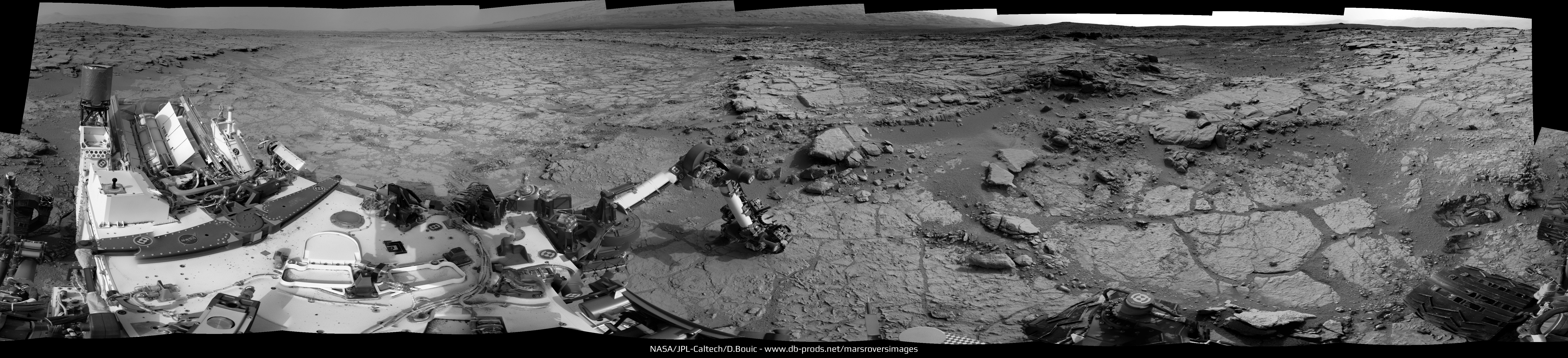
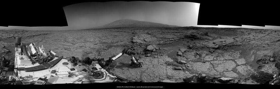
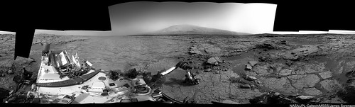
Sol 168 Navcam left full 360-degree panorama. Great view of the Yellowknife bay!
Click to view attachment
Full-res: http://www.pictureshack.us/images/32727_s1...left_stitch.jpg
Interactive panorama: http://photosynth.net/view.aspx?cid=1973d6...79-ae51e1dae9bf
Do you guys thing Yellowknife bay used to be a small lake at some point?
Click to view attachment
Full-res: http://www.pictureshack.us/images/32727_s1...left_stitch.jpg
Interactive panorama: http://photosynth.net/view.aspx?cid=1973d6...79-ae51e1dae9bf
Do you guys thing Yellowknife bay used to be a small lake at some point?
Just one more frame to go, and the full panoramic will be complete .
.
.
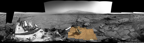
Color view of sol 168's proceedings (with some APXS action) via a Mastcam-34 pano:
Click to view attachment
This same target shows up as brushed on sol 169, but was it already brushed for the sol 168 APXS observation?
Airbag
Click to view attachment
This same target shows up as brushed on sol 169, but was it already brushed for the sol 168 APXS observation?
Airbag
Hey folks. I took 6 of the left HazCam images and made them into an animated GIF (Sol 169).
But... Do I see a star, planet, or moon directly over Mount Sharp in the last 3 or so frames?
That would be cool if it weren't an artifact...
http://makeagif.com/media/1-26-2013/wJFQCl.gif
Edit - I appreciate the answer below. Thanks...
But... Do I see a star, planet, or moon directly over Mount Sharp in the last 3 or so frames?
That would be cool if it weren't an artifact...
http://makeagif.com/media/1-26-2013/wJFQCl.gif
Edit - I appreciate the answer below. Thanks...
QUOTE (iMPREPREX @ Jan 26 2013, 05:52 PM) 
But... Do I see a star, planet, or moon directly over Mount Sharp in the last 3 or so frames?
One test - does it also show up in the corresponding right hand image? It does not in this case, so it must be an artifact specific to the left hand image (plus the sky is too bright for any such object anyway).
Airbag
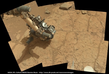
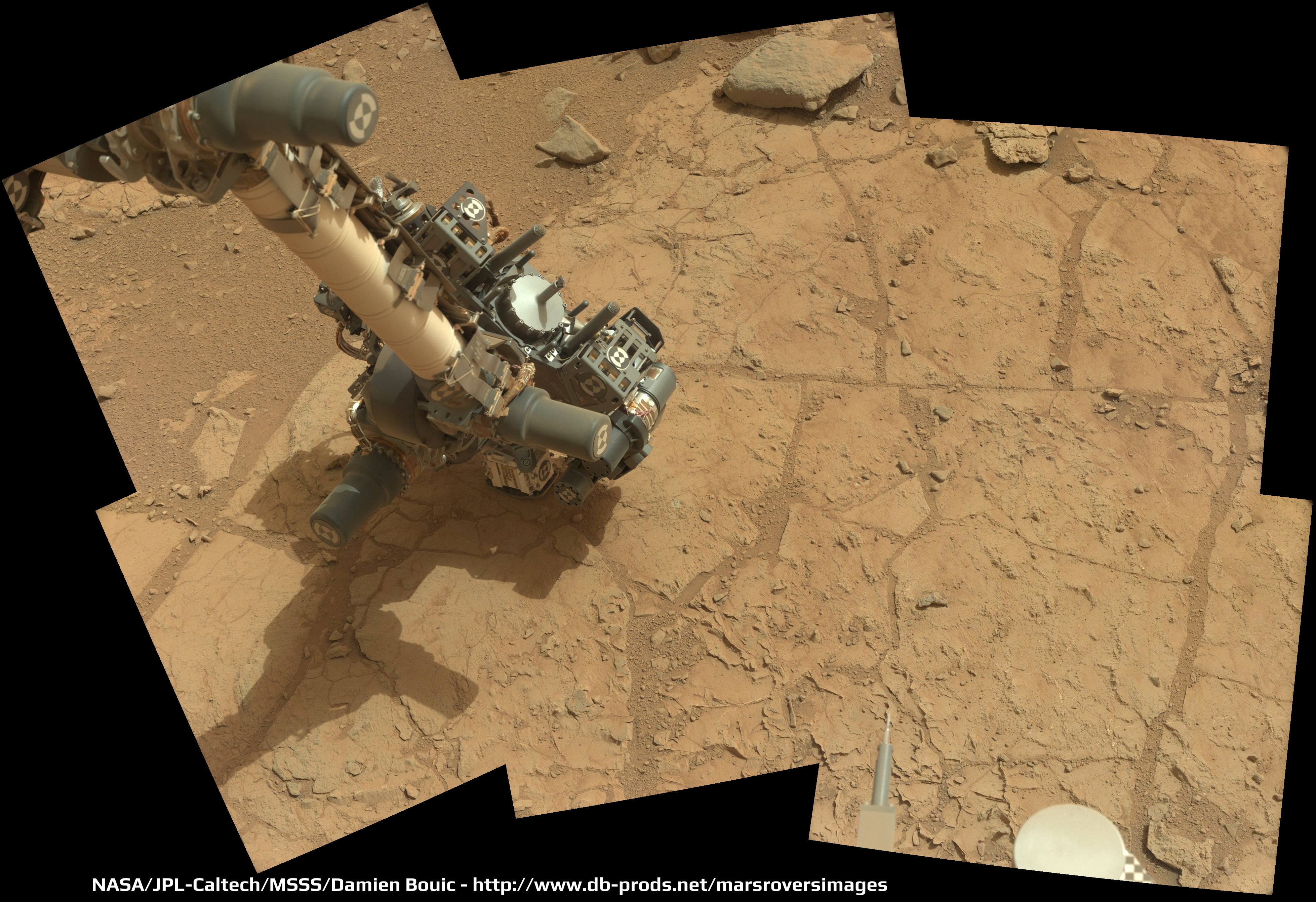
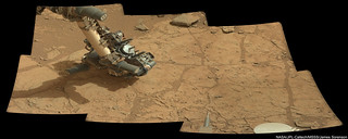
My take on Sol 168 color mosaic of the robotic arm analysing the soil with the APXS tool :
QUOTE (iMPREPREX @ Jan 26 2013, 02:52 PM)
But... Do I see a star, planet, or moon directly over Mount Sharp in the last 3 or so frames?
No.
http://mars.jpl.nasa.gov/msl-raw-images/pr...FHAZ00206M_.JPG
http://mars.jpl.nasa.gov/msl-raw-images/pr...FHAZ00206M_.JPG
Compare the two. It's an imaging artifact
Yeah, I definitely found out the hard way on that one. Sorry folks. 
QUOTE (Ant103 @ Jan 26 2013, 12:59 PM)
Just one more frame to go, and the full panoramic will be complete .
.In case the missing frame doesn't turn up, you can cheat by using a cropped version of this frame: http://mars.jpl.nasa.gov/msl/multimedia/ra...754M_&s=168 as it gives the required coverage.
Here's a crop of the resulting panorama, although the software I use (Microsoft ICE) hasn't done a very good job. Maybe you can do better.
Click to view attachment
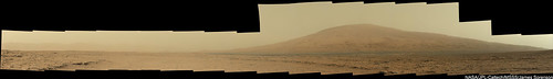
How about seeing Mount Sharp in this panorama ?
Zooming in (animation) on the brushed area (this was the same area that was analyzed with the APXS on sol 168):
Click to view attachment
Airbag
Click to view attachment
Airbag
And the obligatory postcard :
A couple anaglyph perspective views, facing southeast and south:
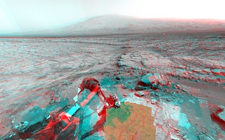
MSLSol168AnaglyphView on Flickr
MSLSol168AnaglyphViewSouth on Flickr
MSLSol168AnaglyphView on Flickr
MSLSol168AnaglyphViewSouth on Flickr
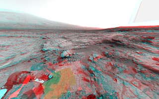
Stunning views everyone. Ahhh yes... Mt. Sharp. Here's yet one more in 3D...

With so much time spent scrutinizing ground details, whenever the whole of Mt. Sharp can be integrated into the view, it just reminds one of things to come; getting over to that behemoth and uncovering it's majesty and mystery close up. Taking a step back in perspective, it still astonishes me how remarkable it is that this incredible machine was actually flown to - and landed safely - in this amazing place.

With so much time spent scrutinizing ground details, whenever the whole of Mt. Sharp can be integrated into the view, it just reminds one of things to come; getting over to that behemoth and uncovering it's majesty and mystery close up. Taking a step back in perspective, it still astonishes me how remarkable it is that this incredible machine was actually flown to - and landed safely - in this amazing place.
QUOTE (Ant103 @ Jan 27 2013, 03:05 PM)
How about seeing Mount Sharp in this panorama ?
Stunning view! Here's a Photosynth for you folk: http://photosynth.net/view.aspx?cid=a66e3c...6e-0dbbb8678e15
Here is my versions of these lovely Navcam and Mastcam Panorama's
EDIT: I like this view XD
EDIT: I like this view XD
Sol 170 front hazard cams show positioning exercises being done with the drill.
Click to view attachment
Also, looking at Herkenhoff's USGS blog they seem to have finished most of the activities needed before pressing in for the kill so to speak. There are two favoured targets according to the sol 167 blog post.
BTW loving the views James . Awesome.
Click to view attachment
Also, looking at Herkenhoff's USGS blog they seem to have finished most of the activities needed before pressing in for the kill so to speak. There are two favoured targets according to the sol 167 blog post.
BTW loving the views James
. Awesome.
Hugin rectilinear projection of APXS measuring the potential drill site--click for zoom.it version:

168 & 169 updated with the latest frames :
Region of a MAHLI sol 169 image with brightness stretched almost to black/white:
Click to view attachment
Click to view attachment
MAHLI mosaic, sol 168--click for zoom.it version:

Looking at the brushed area in 169 and 170 images, it looks as if the target was brushed twice on sol 169, with the DRT offset a bit between them, and then a third brushing across the middle of them on the same sol. Then on 170 the left end of the brushed area was brushed again.
Phil
(Thanks jmknapp for that nice mosaic and your new route plot in the map thread)
Phil
(Thanks jmknapp for that nice mosaic and your new route plot in the map thread)
There are two sets of very similar (other than time of day) MAHLI images from sols 170 and 171, and based on what I read here I assumed they were the before and after images of where the drill's "stand off" (pre-load) posts were in contact with the surface. And sure enough, what I think must be the characteristic tell-tale indentations of the tiny spikes on the posts are visible in for instance these areas:
Click to view attachment
Close ups before and after (animations):
Click to view attachment
Click to view attachment
I will leave it as an exercise for the reader to find the equivalent sets in the other three image pairs
Airbag
Click to view attachment
Close ups before and after (animations):
Click to view attachment
Click to view attachment
I will leave it as an exercise for the reader to find the equivalent sets in the other three image pairs
Airbag
Anyone know which direction (wrt MAHLI images) the DRT brushes rotate? Have some concretions become dislodged since brushing?...
As of sol 166 they've incremented the site counter to 6, and it now seems that they do that when they're getting ready to stay a while and do some serious sampling activity. (They incremented to 4 when they pulled up to the CAP 2 spot on sol 29, and to 5 when they arrived at Rocknest for the first soil sample on sol 57.) So it seems to me to be a good spot to break off the "traveling to Glenelg" thread and start a new one. Happy drilling, Curiosity!
Here's a link to the current position in the Route Map thread.
Here's a link to the current position in the Route Map thread.
and the last set:
Click to view attachment
The second point in the post two above is still eluding me...
Phil
Click to view attachment
The second point in the post two above is still eluding me...
Phil
A sneek peak at the Beautiful 360 degree Mastcam panorama that Curiosity took on Sol-170.
This is a mash-up of several images - jmknapp's MAHLI mosaic, James Sorenson's recent mosaic, and some of the recent sites noted above. There's one more image with drill press marks that I have not yet found on here. (it's off to the lower left from here)
Phil
Click to view attachment
Phil
Click to view attachment
... and now all the locations (except the one I can't see yet) plotted on Edtruthan's mosaic.
Phil
Click to view attachment
Phil
Click to view attachment
QUOTE (elakdawalla @ Jan 28 2013, 11:28 PM)
As of sol 166 they've incremented the site counter to 6...
Normally I don' t bother with the tech talk that goes over my head, but this one is bothering me. Could you explain the purpose of the site counter and what incrementing it means?
QUOTE (Phil Stooke @ Jan 29 2013, 01:38 PM)
... and now all the locations (except the one I can't see yet) plotted on Edtruthan's mosaic.
Phil
Phil
You get an "A-" Phil; it would have been an full "A" if you had found the last one too
BTW, I just came across a wonderfully detailed document about the drill and its testing for all you fellow gearheads out there.
Airbag
The site counter tells you what coordinate system is being used to locate the rover and targets. Back at the landing site the first images could be used to make a base map showing where everything is, so the cameras, ChemCam etc. can be pointed to specific locations. After the rover drove a short distance on sol 16, and again on sol 21, the same coordinate system still works for new observation planning. But eventually you get too far away and you have to set up a new coordinate system. That's a new site. The counter gets incremented as each new one is established.
Spirit and Opportunity have had hundreds of sites between them. Eventually Curiosity will have lots as well.
Phil
Spirit and Opportunity have had hundreds of sites between them. Eventually Curiosity will have lots as well.
Phil
QUOTE (centsworth_II @ Jan 29 2013, 01:02 PM)
Could you explain the purpose of the site counter and what incrementing it means?
Funny you should mention it, looks like it's explained here (see the last three paragraphs or so).
This isn't something new to MSL, by the way; the same system is used on MER, and
(Oops, didn't see Phil's earlier post.)
QUOTE (mhoward @ Jan 29 2013, 02:22 PM)
Funny you should mention it....
Oy! Thanks to you and Phil for the explanations and thanks for the link. That's what happens when one fails to keep up with Emily's blog! An unusual lapse on my part.QUOTE (centsworth_II @ Jan 29 2013, 11:02 AM)
Normally I don' t bother with the tech talk that goes over my head, but this one is bothering me. Could you explain the purpose of the site counter and what incrementing it means?
It is a convenience. After you drive for a while, the rover coordinates, and the coordinates of various targets, start to have many significant digits and it is easy to make mistakes when manually checking large numbers. Therefore, we periodically reset the origin of the coordinate system and we refer the new X, and Y coordinates to the new "site index" to avoid confusing the same coordinates but relative to a different origin. These coordinate systems are always parallel to each other, that is, X is always pointed to North and Y is always pointed to East but the location of coordinate 0, 0 changes at each site index.
Paolo
ChemCam views of the drill bit coming down now! Neato.
This one begs the question, which one is scarier to have pointed at you -- a percussive drill or a laser beam?
This one begs the question, which one is scarier to have pointed at you -- a percussive drill or a laser beam?
This is a "lo-fi" version of our main content. To view the full version with more information, formatting and images, please click here.